
Last updated: 2026-11-11
Design a Budapest Map Poster
Start Your Budapest PosterOrder this print
Free to design · Printed posters from $24.99, shipping included to 20 countries
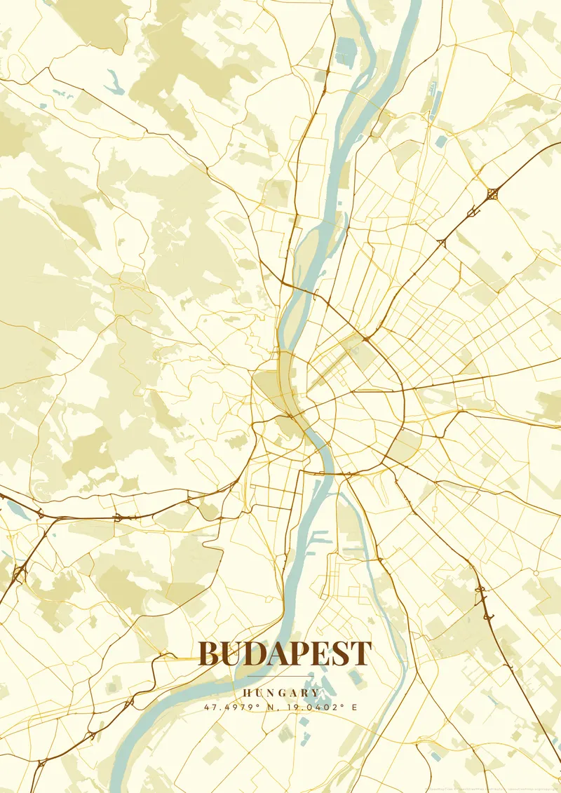
Budapest was created in 1873 by the merger of three cities: Buda (hilly, medieval, on the western Danube bank), Óbuda (ancient Roman Aquincum, northwestern bank), and Pest (flat, commercial, on the eastern bank). The Danube at this point is 300, 400m wide, and nine bridges now connect the two sides. Elizabeth Bridge, Chain Bridge, and Liberty Bridge are especially elegant structures. Castle Hill rises 60m above Pest, topped by the restored Buda Castle and the Fishermen's Bastion.
Budapest — the city's layout
Budapest's Parliament Building (1904, 691 rooms, 96m dome) is the third-largest parliament building in the world by floor area. The city's thermal bath culture, fed by 120 natural hot springs, is unique in Europe; the Széchenyi Baths (1913) and Gellért Baths (1918) are masterpieces of Neo-Baroque architecture. The Danube Banks are an UNESCO World Heritage Site. For a map poster, the dual-city geography divided by the Danube, with Castle Hill and Parliament visible in a single frame, is deeply compelling. Imperial gold, deep Danube blue, or brasserie amber tones beautifully reflect Budapest's extraordinarily rich and layered character.
On the Pest side, two boulevards trace concentric curves out from the river. The inner Kiskörút follows the line of the medieval city wall, and the outer Nagykörút, or Grand Boulevard, makes a wider arc between Margaret Bridge and Petőfi Bridge. Andrássy Avenue cuts straight across both, running northeast from the inner city to Heroes' Square and the City Park (Városliget). Between the boulevards, the Jewish Quarter in Erzsébetváros has a dense network of narrow streets and courtyard buildings. In the river, Margaret Island stretches between Margaret and Árpád bridges as a long, green parkland. In Buda, Gellért Hill rises at the southern end of the river bend, with the Citadella at the top, and the wooded Buda Hills climb to János-hegy, the city's highest point. Farther south, Csepel Island splits the Danube. A tight frame on the inner city shows the boulevards; zooming out adds Margaret Island and Csepel.
Budapest at a glance
- Where: Central Hungary, Hungary, at 47.50° N, 19.04° E.
- Mapped area: Budapest's boundary in OpenStreetMap spans about 29 km north to south and 31 km east to west.
- Nearest cities with a page: Bratislava (160 km), Vienna (210 km), Krakow (290 km).
Printed and shipped to your door
Design your Budapest map poster for free, then order it printed from the same editor. Posters print at 300 DPI on 170 gsm silk paper (A4 on 350 gsm card), and tracked shipping to 20 countries is included in every price. Each print is made to order within 3 business days, then usually arrives 3 to 6 business days after it ships (longer to Canada, Australia, Norway, New Zealand, Japan, Brazil and Mexico).
| Size | Dimensions | Poster |
|---|---|---|
| A4 | 8.3 × 11.7″ | $24.99 |
| 12 × 18″ | 30 × 46 cm | $34.99 |
| 16 × 20″ | 41 × 51 cm | $39.99 |
| 18 × 24″ | 46 × 61 cm | $44.99 |
| 12 × 12″ | 30 × 30 cm | $29.99 |
| 20 × 20″ | 50 × 50 cm | $44.99 |
Also framed (black, white or oak) from $79.99, on canvas from $69.99. Prices in USD, shipping included; checkout switches to EUR or GBP based on where you are. A print that arrives damaged is reprinted or refunded for free.
Frequently Asked Questions
Can I order a printed Budapest map poster?
Yes. Design your Budapest poster, then choose Order this print in the editor: a poster from $24.99, framed or on canvas, with tracked shipping to 20 countries included.
Can I print a Budapest map poster at home?
Yes. Download your Budapest poster and print on thick matte or glossy photo paper. The standard version works well up to 8×10″, and the high-resolution export is sharp up to 18 × 24″ or A2. Or let us print it: printed posters from $24.99 with shipping included, framed or on canvas too.